We woke to the sounds of a distant farm truck lumbering crates of summer oranges over the narrow wooden and iron bridge which crosses the Murray and links Victoria with New South Wales at Tooleybuc.
Breakfast! I got the campfire going and boiled the billy, Juliette toasted bread with a forked stick over the coals. Toast and Vegemite, tea and coffee.
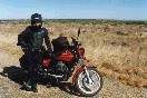
It didn't take us long to pack up the bike, and then we too crossed over into NSW, where the highway turned north-east and then north, keeping the rising sun on the horizon out of our eyes and to our right as we headed for Balranald.
This small town (pop 1400) astride the Murrumbidgee River entertained some early and eventually unfulfilled promise as a river port.
Though 500 kilometres from the coast as the crow flies (and twice as far as the river flows), Balranald is just 60 metres above sea level. And while the Hay Plains, which extend east from Balranald for almost 300 kilometres, are as dry as a pub with no beer, the Murrumbidgee crosses this plain from roughly east to west. Here it receives practically no new water - it is fed from the higher rainfall areas far to the east.
In fact, the Murrumbidgee loses, not gains, water as it crosses the Plains. Like the Murray, its waters are plundered for irrigation. The irrigation canals take so much water from this, the Hay Plains' only river, that even rice is grown in this semi-desert., and mobs of wild emus fall to farmers' rifles as they protect their precious rice paddies.
The flightless emus, one of the world's tallest and heaviest birds, were once numerous in these parts and many flocks survive. They manage better here than they did in Western Australia, where they were regarded as a pest to such an extent that they provoked the notorious "Emu War" of 1932, when a detachment of army soldiers was dispatched with two Lewis guns and orders to exterminate their feathered enemy. Not for nothing did the World War One diggers wear emu plumes in their slouch hats.
But predation of emus started well before Europeans; the first stone-age hunter-gatherers who arrived on this continent found them easy prey and slaughtered them in their tens of thousands. Emus' natural curiosity meant they could be lured within spear range simply by climbing a tree and lowering a ball of feathers, which the birds would come to investigate. They were then speared from above. The struggling of the wounded victims would then attract more curious birds to the killing ground.
Australia once possessed an even larger, far more ancient flightless relative of the emu, one which stood up to three metres high - the Genyornis. Researchers have used a dating technique known as racemization on fossil Genyornis eggshells, in which changes in the shells' amino acids act as geological clocks. They also used radiocarbon dating and the decay of uranium to date the fossil eggshells directly. And they used a luminescence dating technique to measure changes in quartz grains caused by trace levels of background radiation.
The dates suggest it was not a climatic change which caused these extinctions - it was the sudden arrival of a new, bipedal carnivorous ape from Africa. More than 85 percent of the Australian megafauna weighing more than 50 kilos became extinct at about the same time. The list includes 19 species of marsupials over 110 kilos, including a hippopotamus-sized relative of the wombat, an eight metre-long, one metre-diameter snake, a nine metre- long lizard and a Volkswagen-sized giant horned tortoise. Although debate continues over the precise dates for many of the extinctions, the evidence for extinction of Genyornis is more clear.
A research team from University Of Colorado reported on more than 700 dates of Genyornis eggshells from three climatic regions and documented their presence from more than 100,000 years ago, to their sudden disappearance about 50,000 years ago - shortly after humans arrived in Australia.
Some researchers blame deliberate burning of the grassland and woodland by these new, efficient killer primates. Others suggest the megafauna were easy prey, having evolved without human hunters, and therefore having no fear of them. The debate over the megafauna extinctions in Australia is similar to the debate over North American megafauna extinctions which happened some 13,000 years ago. The North American extinctions occurred soon after PaleoIndians first arrived on the continent.
In 1994, excavations at Cuddie Springs, near Carinda in central northern New South Wales, exposed numerous bones of the now extinct megafauna, including the Genyornis and a large wombat-like creature as big as a rhinoceros called Diprotodon. Alongside the bones were considerable numbers of stone tools, charcoal, and other indicators of human activity. The bones and stone tools found in the same horizons at Cuddie Springs are evidence from Australia for the interaction and overlap (in time) of people and megafauna. The megafauna died out in Australia soon after the aborigine arrived, just as the megafauna of Europe, the Americas, and Asia did, with the coming of this terrible new, well-armed, walking hunter.
Today's emus are omnivorous, eating a variety of grasses, fruits and flowers of native plants, and insects. During grasshopper plagues their diet consists almost exclusively of locusts. But to their cost, they have also developed a fondness for rice.
I've shot and eaten emu while opal-mining at Lightening Ridge. Burke and Wills ate a couple of emus too, but they are no longer here to tell the tale. They set out in 1860 from Royal Park in Melbourne, aiming to be the first to cross the continent from south to north. They had with them 27 camels imported specifically from India (with three sepoy attendants), 28 horses, several wagons, 14 men, and enough salted meat, vegetables, and lime juice to keep the explorers alive for a year and a half. (The second-in-command, George Landells, insisted on bringing 60 gallons, about 280 litres, of rum "for the camels", claiming it would keep them free of scurvy.) Among the 22 tonnes of baggage were sufficient weapons and ammunition to live off the land, if they included emu in their diet.
By the time the expedition reached Balranald, four weeks later, Burke was anxious to keep ahead of a similar party racing north from Adelaide which was also eager to win the trans-continental race. So here in Balranald on September 15, 1860, Burke dumped his "excess" supplies, which included the lime juice but not the rum. He also frightened the Balranald horses with his camels, and a century and a half later, the horses have learned to be more contemptuous of strange transport - they barely looked up at the passing Moto Guzzi.
Rule #108 of good motorcycling touring is to never stop at a highway petrol station on the outskirts of a town. It's best to go into the town itself, specially if the highway bypasses the town, and to go where the locals go. We turned off the highway, across the bridge which spanned the Murrumbidgee River. The Murrumbidgee, a tributary of the Murray, rises on the eastern slopes of Mt Kosciusko, flows north through Canberra in the Australian Capital Territory and then meanders west across the plains of NSW before joining the Murray 40 kilometres to our east. Did Juliette know, as we now rode across the Murrumbidgee bridge on our approach to Balranald, that this was the same river on which she and I and the rest of the family, with Taps swimming behind, had gone canoe-ing ten years ago, 20 minutes from where we then lived in suburban Canberra?
I would have asked her, but such conversations are difficult on a bike. When you travel with someone special as your pillion, you often think of things you'd like to say, and then the scenery changes or the moment passes, and it's unsaid and eventually forgotten. Certainly it's possible to slow down, lift the visors, and shout a sentence or two, but usually communication consists of a point, and a nodded acknowledgment. Yet there is something quite intimate about having someone you love on the back of your bike, and there's a level of communication that transcends speech, or even signals. There is a bond established, a bond of experiences shared, of sights enjoyed, of the senses in harmony. You can even feel when your pillion's arse gets sore, as they move around on the seat. And there's the joy of responsibility, of knowing the trust someone puts in you, knowing that you'll look after them, and carry them safely.
Into the main street, and we pulled in at a service station and shop. Here we had morning tea, toasted ham and cheese sandwiches, coffee served in porcelain cups, and I met John Kerin, The Australian's federal political reporter, on his way from Canberra to Adelaide. We chatted, talked politics and travel, and then jumped on our bikes again, to head east across the Hay Plains along the Sturt Highway.
The Hay Plains extend hour after hour. So much of the original vegetation has now been cleared that it's easy to believe it has always been treeless, but this is not the case. Small patches of low woodland still exist, usually near the scattered homesteads, and saltbush grows abundant. Flocks of galahs screamed as they flew overhead, and freckled and black ducks ventured into view from the Murrumbidgee River, which was out of sight to our north, running parallel to the highway. For kilometre after kilometre, the scenery was changeless. And desolate. And enjoyable.
The mind runs free on tour through featureless country. It's as if it were as unconstrained as the scenery. Thoughts give way to other thoughts, until one finds oneself thinking of new things, or of old things in new ways, and - sometimes, touring on a motorcycle - it's possible to backtrack and rediscover (with surprise) by what route one arrived at a particular thought. Luxury. It's almost free association, and when Hay finally appeared it was something of an intrusion.
Hay is also on the Murrumbidgee River, and on the junction of three Highways, the Mid-Western, the Cobb, and the Sturt. The Cobb was named after the famous coaches, and one of the original Cobb & Co coaches, the Sunbeam, which did the Deniliquin-Hay-Wilcannia run until 1901, is proudly displayed in the original coach-house on the main street. The Sturt Highway follows the Murrumbidgee, and is named after Charles Sturt, who in 1829-30 was the first European to navigate the river. Just east of the town is a box tree which still bears his blaze, and the date. And the Mid-Western is named after... well, it just is.

Juliette and I sat on the footpath, eating a take-away. It was getting warm, but not unpleasantly so, which was just as well, because there's a saying that the three hottest places in New South Wales are Hay, Hell, and Booligal, in that order. Booligal, on the Lachlan River (a tributary of the Murrumbidgee, and therefore of the Murray) 80k north of Hay and on the Cobb Highway, gets bad media - Banjo Patterson's poem "Hell, Hay, and Booligal" has the line:
"... To say it's worse than Hay or Hell,
But you don't need to talk at all;
Of course, there's heat - no one denies -
And sand and dust and stacks of flies,
And rabbits too, at Booligal."
So we gave Booligal a miss, and headed north-east along the Mid-Western Highway for Wyalong.
But to get to Wyalong, one first has to pass through West Wyalong - that is, if one comes from the west, as we were. West Wyalong is in the centre of the prosperous wheat, wool, and mixed farming area through which we'd just ridden under a blue sky, but before that, in 1893, it was a gold-mining town. Ten thousand diggers scratched the soil here until the gold completely ran out in 1914. Wyalong was intended to be the main town, but its gold exhausted itself earlier and there was found to be more water at the "main camp", which became West Wyalong. We stopped at West Wyalong, and had some tucker and a coffee and consulted the map. Which way should we go from here? West Wyalong is also at the junction of two highways, the west-east Mid-Western Highway, and the north-south Newell Highway. It was decision time.
A bloke pulled up at the park while we deliberated. He had a bike too, he told us. It was a BMW four-cylinder, but he had an instant and embarrassing mental blank and couldn't remember the model, although it had just taken him from West Wyalong to Darwin, through Mt Isa and Queensland, and back home again. He always stops for motorcycles he said, but for the life of him he couldn't remember what model of four-cylinder BMW he had. He was a bus driver, taking tourists to Hay and back again. Sometimes he took tourists from Hay to West Wyalong and back again, but damn, what was that model of BMW? He knew it so well, he said, now what was it again? Perhaps a K series, I suggested. Yes, that sounded familiar. He looked at my map and pointed out Hay, where he, he said again, sometimes took tourists, and at West Wyalong, where he, he reminded us, also took tourists, but he still couldn't remember what model BMW he owned, and it was really bugging him. He told us about tourists and Hay and West Wyalong for the third time. It was safer to be on familiar ground.
Meanwhile, I couldn't decide on the route... it was too distracting having him point to Hay and West Wyalong without being able to remember which BMW he owned. So we packed up the thermos and made it three kilometres along the Newell Highway to Wyalong proper, where we stopped at the pub, bought some take-away beer, sat on the footpath, and drank with the devil.
Juliette was the first to observe that Wyalong seemed to be a bit of a devilish town. Everywhere she looked she saw the number 666. Even over the road, the Jehovah's Witness Kingdom Hall had a devil-red car parked outside a derelict building with the number 6 prominently displayed.
So we gulped our sinful beer, and, minds made up, headed east for Grenfell and Cowra. This meant our route would take tomorrow's approach to the Great Dividing Range through the Wollemi and Barrington Tops ranges. Nice country.
And nice country for riding, as we left both Wyalongs. Now the vegetation grew more luxurious, and single trees, and then whole stands, of Western Cypress appeared. The white cypress league is the most important group on the inland side of the Great Dividing Range in NSW, and while the areas in which is grew have been cleared for pasture and agriculture, huge forests the size of small European countries (like Nederland) of this pine remain. This is the tree which grows in the Pilliga Scrub near Coonabarabran, and ...Inglewood. It's one of my favourite trees. And we could see other large trees, the fuzzy box and the bimble box, and silver-leafed, narrow-leafed, blue-leafed and red ironbarks. There were native rough and smooth-barked apples, black cypress pine, and she-oaks.
We opened the throttle a little. In my helmet I sang songs. I was happy.
 Distant low ranges became pleasurable hills over which to pass, and soon it
was late afternoon. Galahs played aerial acrobatics overhead, and
sulphur-crested cockatoos called raucously in flight. We passed through
Grenfell, also an early gold-mining town. One of the prospectors had been
Peter Larsen, who pitched his tent here and whose wife gave birth, in that
tent, to a son who would become the poet Henry Lawson.
Distant low ranges became pleasurable hills over which to pass, and soon it
was late afternoon. Galahs played aerial acrobatics overhead, and
sulphur-crested cockatoos called raucously in flight. We passed through
Grenfell, also an early gold-mining town. One of the prospectors had been
Peter Larsen, who pitched his tent here and whose wife gave birth, in that
tent, to a son who would become the poet Henry Lawson.
There were other ways of getting gold than digging for it, of course. The Weddin Mountains, visible to our south, was a hangout for Ben Hall, Frank Gardiner, and Johnnie Gilbert - bushrangers all. We didn't visit Ben Hall's cave, though it's open to the public (which it wasn't in Ben Hall's time).
And then eastwards still, through Cowra on the Lachlan River (just like Booligal is, though a day's ride to the west). As we rode over this bridge I thought of these waters emerging at Lake Alexandrina years from now, because the Lachlan, of course, also flows into the Murrumbidgee and therefore into the Murray. Or would the waters be pumped out, and sprayed on irrigated crops?
Finally, with the sun getting low, we rode through Bathurst, scene of NSW's biggest goldrush, Australia's oldest inland city, and on the western slopes of the Great Dividing Range.
It was over that range, that we were headed tomorrow.